
Features Relevamiento Vial
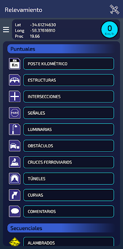
Road inventory survey by georeferencing for Argentine national routes.1.
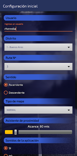
To begin, you are required to enter an identifying user, and complete the data on the Configuration screen.2.
It has a linear distance measurement tool that allows, for example, measuring the length of a bridge or large linear paths.3.
In all surveys you may take photographs, which are incorporated into the data surveyed.
You can also view them in the application, as well as all the data collected.4.
Generates plain text files with all the information collected, which can be downloaded from the mobile phone and edited with Microsoft Excel.
Likewise, you can send them through the applications own email.5.
On the Map you can view the icons of each survey, you can also drag and drop any icon that needs to correct its location, or delete it, if you wish.6.
When traveling the inventoried route, the Proximity Assistant will indicate, depending on the warning distance configured, when you are close to an inventory item.7.
Request for location permission at all times: It is only used, if the user activates it, for the event proximity assistant on the MAP screen, to receive notifications with the screen off.
This functionality is enabled/disabled by the user, and background location is permanently disabled when closing the MAP screen.
All app location is disabled upon termination.
Camera Features
Advanced camera features with editing capabilities.
Travel Features
Plan and manage your travels with ease.
Offline Mode
Use the app without an internet connection. Your data syncs when you're back online.
See the Relevamiento Vial in Action

Get the App Today
Available for Android 8.0 and above